Reality Capture & BIM Integration with Surveying & Mapping Drones: Transforming Construction Workflows Through Intelligent Aerial Data
The construction industry is rapidly embracing digital transformation, and Reality Capture & BIM Integration has become one of the most valuable workflows for improving project planning, construction quality, and long-term asset management. Traditional surveying methods often rely on isolated measurements and labor-intensive fieldwork, making it difficult to maintain an up-to-date representation of complex construction sites.
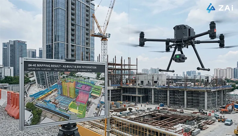
Today, Surveying & Mapping drones have fundamentally changed this process. Equipped with high-resolution cameras, drone LiDAR systems, RTK positioning, and intelligent flight planning capabilities, modern drones capture comprehensive three-dimensional spatial information quickly and accurately. The collected data seamlessly integrates into BIM platforms, allowing engineers, surveyors, architects, and project managers to work from an accurate digital representation of real-world conditions throughout every project phase.
As an experienced industrial drone manufacturer, HongKong Global Intelligence Technology Group Limited provides enterprise drone solutions designed to support complete Reality Capture & BIM Integration workflows for infrastructure, commercial developments, industrial facilities, mining operations, transportation projects, and smart city construction.
Why Reality Capture Matters in Modern Construction
Reality Capture refers to the process of creating highly accurate digital representations of physical environments using aerial imagery, laser scanning, and photogrammetry.
Rather than collecting individual survey points, construction drones generate complete spatial datasets including:
High-density Point Clouds
Photorealistic 3D Mesh Models
Digital Surface Models (DSM)
Digital Elevation Models (DEM)
Orthomosaic Maps
Digital Terrain Models (DTM)
When integrated with BIM, these datasets become a continuously updated digital foundation for planning, monitoring, verification, and facility management.
How Surveying & Mapping Drones Support Reality Capture Throughout the Project Lifecycle
Site Survey & Scan-to-BIM During Project Planning
Drone Lidar from ZAi
Before construction begins, obtaining an accurate understanding of existing site conditions is critical. Traditional surveys can require days or even weeks depending on project size.
Using Surveying & Mapping drones, project teams perform comprehensive aerial surveys through photogrammetry or drone LiDAR scanning.
The captured point cloud data can be imported directly into BIM software such as Autodesk Revit to generate accurate As-Built models of existing structures.
This workflow supports:
Existing building documentation
Reverse engineering
Site planning
Earthwork estimation
Utility mapping
Terrain analysis
Foundation design
LiDAR systems are particularly valuable when surveying forested, uneven, or vegetation-covered sites because laser pulses can penetrate gaps in vegetation to capture the true ground surface.
Continuous Construction Monitoring with 4D BIM
Construction projects constantly evolve, making regular documentation essential for schedule management.
By conducting weekly or monthly drone flights, project teams create updated 3D site models that are compared against planned BIM schedules.
This enables:
Progress verification
Schedule validation
Contractor performance monitoring
Material stockpile measurement
Earthwork Cut & Fill analysis
Equipment deployment optimization
Because the same automated flight path can be repeated throughout the project, datasets remain highly consistent, making progress comparisons both reliable and objective.
If you are looking to implement a customized Reality Capture & BIM Integration workflow for your projects, HongKong Global Intelligence Technology Group Limited can help design a complete drone solution tailored to your construction environment, data accuracy requirements, and BIM platform.
Construction Quality Control & Deviation Analysis
One of the greatest advantages of integrating drone-generated reality capture data with BIM is automated comparison between the designed model (As-Designed) and the completed construction (As-Built).
Using software platforms such as Navisworks or Solibri, engineers can identify discrepancies before they become costly problems.
Common inspection applications include:
Structural alignment verification
Steel frame positioning
Wall placement validation
Road slope inspection
Pipeline routing verification
Bridge component alignment
Roof geometry inspection
Early detection significantly reduces rework costs while improving overall project quality.
Digital Twin Creation for Asset Management
The value of Reality Capture extends far beyond project completion.
By integrating updated drone datasets with BIM property information, organizations can establish Digital Twins that continuously reflect actual asset conditions.
Digital Twins support:
Facility maintenance
Infrastructure inspection
Building lifecycle management
Emergency response planning
Exterior façade inspections
Utility management
Disaster assessment
Instead of static documentation, owners receive a living digital model that evolves alongside the physical asset.
Core Drone Capabilities Required for BIM Integration
High-quality Reality Capture depends on professional aerial platforms equipped with advanced mapping technologies.
Capability
Importance for Reality Capture & BIM
RTK / PPK Positioning
Delivers 2–5 cm absolute positioning accuracy for precise BIM alignment.
3D Flight Planning & Terrain Following
Maintains consistent GSD across uneven terrain and tall structures.
Mechanical Shutter Cameras
Eliminates rolling shutter distortion during high-speed mapping flights.
High-Resolution Imaging
Produces detailed textures and accurate photogrammetric reconstruction.
Drone LiDAR Payload
Captures dense point clouds and penetrates vegetation for true terrain modeling.
Omnidirectional Obstacle Avoidance
Enables safe operation around cranes, scaffolding, power lines, and buildings.
Long Flight Endurance
Improves productivity by covering large construction sites in fewer flights.
Multi-Payload Compatibility
Supports photogrammetry, thermal imaging, LiDAR, and inspection sensors on one platform.
Navisworks, Autodesk Construction Cloud, Bentley Synchro
GIS Integration
ArcGIS Site Scan
Together, these software platforms transform raw aerial imagery into actionable engineering information that can be shared across multidisciplinary project teams.
Benefits of Reality Capture & BIM Integration
Organizations adopting Surveying & Mapping drones gain measurable improvements throughout the construction lifecycle.
Benefit
Business Impact
Faster Site Documentation
Large areas surveyed in hours instead of days
Higher Spatial Accuracy
Centimeter-level positioning for reliable BIM alignment
Reduced Manual Surveying
Lower labor costs and improved field safety
Improved Project Visibility
Continuous progress updates using repeatable drone missions
Better Quality Assurance
Early identification of construction deviations
Reduced Rework
Resolve issues before subsequent construction phases
Better Stakeholder Collaboration
Supports long-term facility management through Digital Twins
Digital Asset Lifecycle
Supports long-term facility management through Digital Twins
Why Choose HongKong Global Intelligence Technology Group Limited?
Successful Reality Capture depends on more than simply deploying a drone. It requires the right combination of aerial platforms, sensors, positioning technology, workflow design, and BIM integration expertise.
As a trusted industrial drone manufacturer, HongKong Global Intelligence Technology Group Limited delivers comprehensive enterprise drone solutions for surveying, mapping, engineering, and construction professionals. Our systems are designed to support high-accuracy photogrammetry, drone LiDAR mapping, RTK positioning, automated flight planning, and seamless integration with leading BIM and GIS platforms.
Whether your organization is managing infrastructure development, commercial construction, transportation corridors, mining operations, or large-scale industrial facilities, we can customize a Reality Capture & BIM Integration solution that aligns with your operational requirements, accuracy standards, and project objectives. Contact our team today to discuss a tailored workflow that maximizes data quality, streamlines BIM collaboration, and accelerates digital transformation across your projects.
Frequently Asked Questions
How accurate are Surveying & Mapping drones for BIM projects?
With RTK or PPK positioning combined with properly established Ground Control Points (GCPs), professional mapping drones can typically achieve horizontal and vertical accuracies within 2–5 cm, making them suitable for most engineering and BIM applications.
When should drone LiDAR be selected instead of photogrammetry?
Drone LiDAR is particularly effective in areas with dense vegetation, complex terrain, or environments where accurate ground elevation data is required. Photogrammetry remains an excellent choice for capturing highly detailed textures and creating photorealistic 3D models in open environments.
Can drone-generated point clouds be imported directly into BIM software?
Yes. Most Reality Capture platforms export standard formats such as LAS, LAZ, PTS, E57, OBJ, and other compatible files that can be imported into Autodesk Revit, Civil 3D, Navisworks, Bentley applications, and many other BIM workflows.
How often should construction sites be scanned?
Many contractors perform weekly or biweekly drone surveys to monitor progress, validate schedules, measure earthworks, and compare As-Built conditions against BIM models. The optimal frequency depends on project size, construction pace, and reporting requirements.
Technical Consultation & Project Requirements
Share your mission specifications—such as payload capacity, endurance needs, or environmental constraints. Our engineering team will review your data and provide a optimized UAV configuration tailored to your industrial workflow.
HongKong Global Intelligence Technology Group Limited

 English
 français
 Deutsch
 русский
 فارسی
فارسی ไทย
ไทย العربية
 Nederland
 বাঙালি
 Македонија