Earthwork & Stockpile Management: How Construction Drones Turn Site Data into Actionable Intelligence
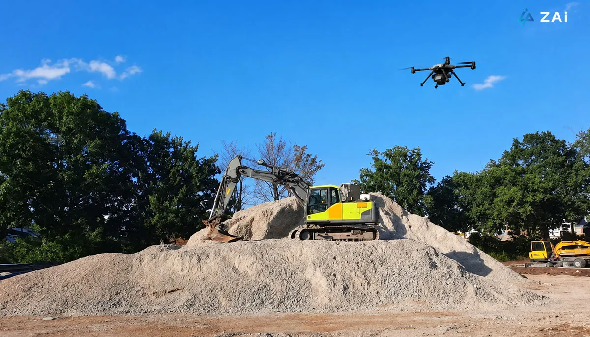
Earthwork is one of the most data-intensive and cost-sensitive stages of a construction project. Excavation, grading, hauling, filling, material storage, and site preparation all depend on one fundamental question: how much material is actually on the ground, and where does it need to go?
Traditionally, contractors have relied on total stations, GNSS/RTK surveys, manual stockpile measurements, truck counts, and periodic site inspections to answer this question. While these methods remain valuable, they can become increasingly difficult to scale across large construction sites, quarries, infrastructure projects, and complex earthmoving operations.
Today, construction drones are adding a new layer of efficiency to this workflow.
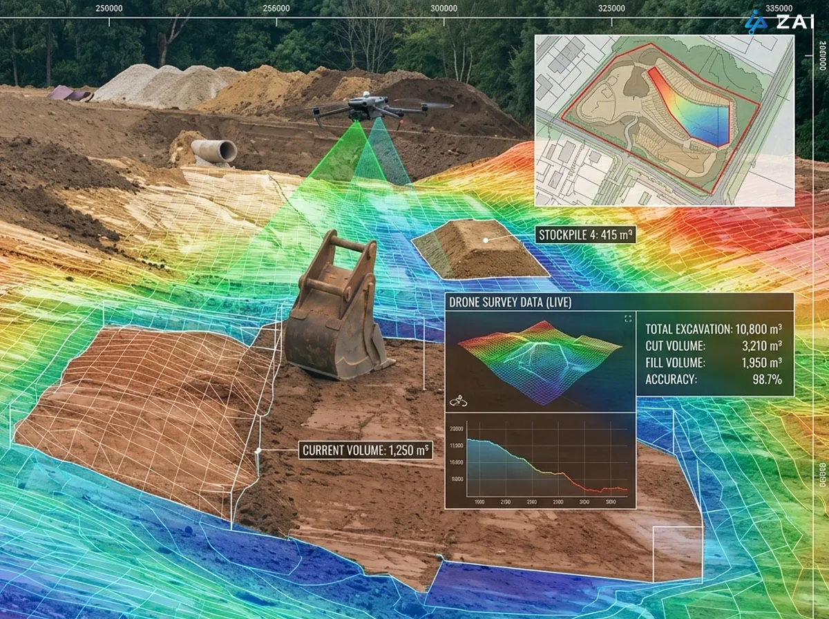
By combining high-precision UAV positioning, photogrammetry or LiDAR, 3D reconstruction, terrain modeling, and earthwork analysis software, contractors can transform aerial survey data into measurable information about cut and fill volumes, stockpile inventory, material movement, site progress, and design compliance.
For projects that require frequent measurements over large or difficult-to-access areas, an enterprise drone can become more than a surveying tool. It can function as a recurring data-collection platform for construction decision-making.
From Aerial Data to Earthwork Intelligence
A typical drone-based earthwork workflow can be represented as:
1
Baseline Survey
2
Weekly/Periodic Drone Survey
3
Updated DTM / Point Cloud
4
Compare with Previous Survey
5
Calculate Material Movement
6
Compare with Design
7
Generate Progress Report
Drone Survey → Photogrammetry/LiDAR → Point Cloud & Terrain Model → CAD/BIM Comparison → Cut/Fill & Volume Analysis → Reporting
The drone captures thousands or millions of spatial data points across the site. These observations are processed into outputs such as:
Orthomosaic maps
Digital Surface Models (DSM)
Digital Terrain Models (DTM)
Dense point clouds
3D meshes
Contour maps
Elevation maps
Stockpile volume reports
Cut-and-fill maps
These datasets can then be compared with design surfaces or previous surveys.
For example, Autodesk Civil 3D supports the creation of TIN volume surfaces by comparing a base surface with a comparison surface. This provides a practical digital foundation for calculating differences between existing terrain and design conditions.
The result is a shift from asking “How much material do we think is there?” to “What does the latest measured surface tell us?”
1. Cut & Fill Analysis: Understanding Where Material Needs to Move
Cut-and-fill analysis is one of the most valuable applications of drones in construction earthwork.
After a drone survey generates an accurate representation of the existing terrain, the resulting surface can be compared against the project's design surface.
The difference between the two surfaces can then be visualized spatially.
Cut Areas
Areas where the existing terrain is above the design elevation represent material that may need to be excavated.
Fill Areas
Areas where the existing terrain is below the design elevation represent areas that require additional material.
Instead of looking only at a final volume number, project teams can use a cut-and-fill heat map to understand where these changes occur.
This information can support:
Excavation planning
Grading operations
Haul route planning
Equipment allocation
Borrow-pit planning
Spoil disposal planning
Material balancing
Contractor progress verification
Autodesk's Civil 3D documentation also recognizes the importance of cut and fill factors because excavated materials can swell while fill materials can compact. In other words, geometric volume alone does not necessarily equal the amount of material that needs to be transported or placed.
This distinction is particularly important for large earthmoving projects.
Earthwork Data Can Support Better Equipment Planning
Once the site surface and material quantities are known, contractors can begin connecting survey data with operational decisions.
For example:
Existing Terrain → Cut/Fill Map → Material Quantity → Haul Route → Equipment Planning → Construction Execution
This can help project managers determine where excavators, bulldozers, graders, scrapers, and haul trucks are needed, while reducing unnecessary movement across the site.
Propeller's earthwork workflow, for example, includes terrain analysis, haul route planning, equipment selection insights, and staging visualization based on site terrain data.
2. Stockpile Management: Turning Material Piles into Measurable Inventory
Stockpiles can represent a substantial amount of project value.
Aggregates, sand, gravel, crushed stone, soil, fill material, demolition materials, and other bulk materials may be stored across multiple locations on a construction site.
The challenge is that a stockpile is not a simple geometric object.
Its height, slope, base surface, shape, and surrounding terrain can change continuously as material is added or removed.
Drone-Based Stockpile Measurement
With a drone survey, the stockpile can be reconstructed as a 3D surface.
The operator can then define the relevant stockpile boundary and base surface to calculate its volume.
The basic workflow is:
Aerial Survey → 3D Point Cloud → Stockpile Boundary → Base Surface → Volume Calculation → Inventory Report
This makes it possible to repeatedly measure the same stockpile and compare the results over time.
Modern earthwork platforms can also calculate stockpile volumes directly from drone survey data. Propeller, for example, states that its workflow can achieve approximately 3 cm drone volume calculation accuracy when paired with appropriate high-precision ground control workflows.
However, an important engineering point should not be overlooked:
Drone measurement accuracy is not determined by the aircraft alone.
Ground control, positioning quality, surface definition, flight planning, image quality, point-cloud processing, and the selected stockpile base surface can all influence the final volume.
Propeller specifically notes that the base surface beneath a stockpile can have a major impact on the resulting volume calculation.
That is why a professional enterprise drone solution should be designed around the entire measurement workflow rather than simply selecting a drone with a high-resolution camera.
3. From Volume to Material Inventory and Cost Control
Once stockpile volume is available, the data can be combined with material density or project-specific conversion factors to estimate tonnage.
For example:
Measured Volume × Material Density = Estimated Material Mass
This can help construction companies maintain a more consistent picture of material inventory.
Regular surveys can also reveal:
Material consumption
Stockpile growth
Material depletion
Unexpected material loss
Changes in storage locations
Stockpile instability
Differences between reported and measured quantities
Instead of conducting a major manual inventory survey only once a month, a contractor can potentially establish a weekly or even more frequent aerial measurement workflow when operational conditions and regulations allow.
Propeller describes drone-based inventory workflows that allow stockpiles to be measured repeatedly and compared against previous surveys, turning inventory reconciliation into a digital process.
For contractors managing multiple material piles, this creates something closer to a digital balance sheet of physical materials on site.
4. Why LiDAR Matters for Complex Construction Sites
Photogrammetry is extremely useful for many earthwork applications, particularly when the ground surface is clearly visible.
But not every construction site is visually straightforward.
Vegetation, uneven terrain, partially obstructed ground, complex structures, and difficult surfaces can make terrain reconstruction more challenging.
This is where LiDAR-equipped construction drones can provide an additional advantage.
Zenmuse L3 for High-Precision Terrain Capture
The Zenmuse L3 is a long-range LiDAR payload designed for the DJI Matrice 400 platform. It combines a 1535 nm LiDAR system with dual 100 MP RGB mapping cameras and a high-precision positioning system.
According to DJI's published specifications, the Zenmuse L3 can achieve a vertical point-cloud accuracy of 3 cm RMSE and horizontal accuracy of 4 cm RMSE at a 120 m flight altitude under specified test conditions. At 300 m, the published figures are 5 cm vertical and 7.5 cm horizontal RMSE. These are laboratory/test-condition figures and should not be interpreted as guaranteed field accuracy for every project.
The system's LiDAR design can also increase ground-point density beneath vegetation, which is useful when the objective is to understand the underlying terrain rather than simply reproduce the visible surface.
For construction earthwork, this can be particularly relevant to:
Large infrastructure sites
Road construction
Complex terrain
Sites with vegetation
Quarry and aggregate operations
Large excavation areas
Terrain monitoring around construction zones
In other words, Zenmuse L3 is not simply a “better camera.” Its value comes from adding another method of measuring the three-dimensional structure of the site.
5. Construction Progress Monitoring Through Repeated Drone Surveys
Earthwork changes every day.
An excavation area that looks almost unchanged from ground level may have experienced significant changes in elevation and material volume.
This makes periodic drone surveying particularly valuable.
A contractor can establish a baseline survey before construction and repeat the same survey weekly, biweekly, or at other project-defined intervals.
The resulting datasets can then be compared through time.
A Typical Progress Monitoring Workflow
This allows project teams to visualize how much material has been removed, where fill has been placed, and whether the actual terrain is moving toward the planned design.
It can also create a more objective record for communication between:
General contractors
Subcontractors
Surveyors
Engineers
Project owners
Quantity surveyors
Site managers
Instead of relying entirely on photographs or written progress descriptions, stakeholders can work from the same spatial dataset.
6. Safer Surveying Around Heavy Equipment and Unstable Stockpiles
There is also a practical safety advantage.
Traditional stockpile measurement may require personnel to work close to piles, machinery, haul roads, or other active construction areas.
Drone surveying can collect much of the required spatial information from the air, reducing the need for survey personnel to physically enter certain hazardous areas.
This does not mean drones eliminate the need for professional surveyors or ground verification.
Rather, they allow teams to use aerial data for the areas where aerial data is most efficient, while reserving ground measurements for control points, verification, and situations where direct measurement is required.
For HSE teams, this can help reduce unnecessary exposure to:
Moving heavy equipment
Active haul roads
Steep excavation areas
Unstable stockpiles
Difficult terrain
Restricted work zones
The most effective approach is therefore not “drone instead of surveyor,” but drone + surveyor + engineering software.
7. What Should a Construction Drone Solution Include?
Selecting a drone for earthwork is not simply about flight time.
A professional enterprise drone solution should be designed around the accuracy, scale, terrain, frequency, and deliverables of the construction project.
Requirement
Why It Matters for Earthwork
RTK / PPK positioning
Improves georeferencing and reduces dependence on manually surveyed points
High-resolution mapping camera
Produces detailed imagery and photogrammetric reconstruction
Mechanical/global shutter
Helps reduce image distortion caused by aircraft movement
LiDAR capability
Useful for complex terrain and areas where ground visibility is limited
Terrain-following flight
Helps maintain more consistent ground sampling across elevation changes
Automated flight planning
Makes repeated surveys more consistent
Large-area coverage
Important for infrastructure and major earthmoving projects
Ground control / checkpoints
Provides independent accuracy verification
3D reconstruction
Converts aerial data into measurable terrain information
CAD/BIM integration
Allows comparison with engineering design data
Volume calculation
Supports stockpile and cut/fill measurement
Historical comparison
Enables progress and material movement tracking
configuration depends heavily on the project.
A compact mapping platform may be sufficient for a relatively small construction site, while a large infrastructure project may justify a higher-end platform with LiDAR and longer-range mapping capability.
8. A Typical Hardware & Software Architecture
A complete Earthwork & Stockpile Management solution can be structured into four layers.
Layer 1: UAV & Sensors
Potential platforms include:
DJI Matrice 4E for compact mapping operations
DJI Matrice 400 for larger industrial survey missions
Zenmuse L3 for LiDAR-based terrain capture
High-resolution photogrammetry payloads for image-based reconstruction
Layer 2: Positioning & Ground Survey
Depending on project requirements:
RTK/PPK
GNSS rover
Ground Control Points (GCPs)
Checkpoints
D-RTK systems
Other survey-grade positioning equipment
Layer 3: Data Processing
The collected data can be processed into:
Point clouds
DSM
DTM
DOM
3D meshes
Contours
Terrain surfaces
Common processing ecosystems include DJI Terra, Pix4D, Agisoft Metashape, and Bentley ContextCapture, depending on the project's data requirements and existing software environment.
Layer 4: Engineering & Analysis
The final data can then be connected with platforms such as:
Autodesk Civil 3D
Bentley MicroStation
Propeller
DroneDeploy
Virtual Surveyor
Other earthwork and construction management platforms
This architecture is important because the drone is only the data acquisition layer.
The real value is created when that data becomes usable engineering information.
9. Building a Customized Earthwork & Stockpile Management Solution
No two construction sites are exactly the same.
A highway project, commercial development, quarry, landfill, industrial park, and large excavation project may all require different flight altitudes, sensors, positioning methods, survey frequencies, accuracy standards, and software workflows.
At HongKong Global Intelligence Technology Group Limited, we can help customers evaluate the complete workflow rather than simply recommending a drone model.
A customized Earthwork & Stockpile Management solution can be designed around:
Project size and terrain
Required measurement accuracy
Cut-and-fill requirements
Stockpile quantity and material types
Survey frequency
Photogrammetry or LiDAR requirements
RTK/PPK and GCP strategy
Existing CAD/BIM environment
Volume calculation requirements
Construction progress reporting
Data storage and collaboration
Integration with existing survey and engineering workflows
For example, a project may use a compact construction drone for frequent site mapping, while a larger or more complex site may combine an industrial UAV with Zenmuse L3 LiDAR for terrain reconstruction.
The objective is not to use the most expensive equipment.
It is to build the right combination of aircraft, payload, positioning, software, and workflow for the actual engineering problem.
If your construction project requires regular earthwork measurement, stockpile inventory, cut-and-fill analysis, or 3D terrain monitoring, contact HongKong Global Intelligence Technology Group Limited to discuss a customized Earthwork & Stockpile Management solution.
10. From Surveying to a Digital Construction Record
One of the longer-term benefits of drone-based earthwork management is the creation of a historical spatial record.
Every survey becomes a snapshot of the site.
Over time, these snapshots can document:
What the site looked like → What changed → How much material moved → Whether the work followed the design → What remains to be completed
This information can support quantity verification, progress meetings, subcontractor coordination, project documentation, and future planning.
For large projects, that historical dataset can become valuable well beyond the original survey.
It can connect drone surveying with broader workflows such as BIM, digital construction management, quantity tracking, and project reporting.
Frequently Asked Questions
How accurate can drone stockpile measurements be?
Accuracy depends on the aircraft, sensor, positioning method, ground control, flight planning, terrain, processing workflow, and especially the definition of the stockpile's base surface.
For example, Propeller reports 3 cm drone volume calculation accuracy under its specified high-precision workflow and states that its survey-grade workflow can achieve approximately 97–99% volumetric accuracy. These figures should be understood as workflow-specific performance claims rather than a universal accuracy guarantee for every drone survey.
Is LiDAR always necessary for construction earthwork?
No.
Photogrammetry can be highly effective when the ground surface is clearly visible and the site conditions are suitable.
LiDAR becomes particularly attractive when terrain complexity, vegetation, ground visibility, or other environmental conditions make image-based reconstruction less suitable.
Can drone data be used with Civil 3D?
Yes. Drone-derived terrain data can be processed into surfaces and other formats that can be incorporated into engineering workflows. Autodesk Civil 3D supports surfaces derived from point-cloud data as well as volume surfaces used to compare terrain datasets.
Can drones replace traditional surveying?
Not completely.
For professional construction projects, drones are best viewed as a complementary surveying and data-acquisition technology. RTK/GNSS equipment, checkpoints, ground verification, engineering review, and other conventional surveying methods can remain important depending on project requirements and local regulations.
How often should a construction site be surveyed?
There is no universal schedule.
A project may require monthly surveys for general documentation, weekly surveys for earthwork progress, or much more frequent surveys for active stockpile inventory and high-volume material operations.
The appropriate frequency should be determined by the rate of terrain change, project schedule, reporting requirements, and the financial importance of the measurements.
What is the best drone for Earthwork & Stockpile Management?
There is no single best drone for every project.
A compact mapping platform may be appropriate for smaller construction sites, while larger projects may benefit from an industrial platform and advanced payload such as the Zenmuse L3.
The better question is: What level of accuracy, coverage, terrain complexity, survey frequency, and data integration does the project require?
That is where a customized enterprise drone solution can provide significantly more value than simply purchasing a drone and conducting aerial photography.
Conclusion
Earthwork and stockpile management are fundamentally about knowing what is on the ground and how it is changing.
Construction drones provide a practical way to collect that information repeatedly and at scale. When combined with RTK/PPK positioning, photogrammetry, LiDAR, 3D reconstruction, CAD/BIM integration, and volume-analysis software, aerial survey data can become a powerful operational resource.
From cut-and-fill analysis to stockpile inventory, from construction progress monitoring to material movement tracking, the technology can help contractors replace fragmented measurements with a more continuous digital view of the site.
For projects where terrain, material quantities, schedule, and cost are closely connected, the real opportunity is not simply to fly a drone.
It is to build an integrated Earthwork & Stockpile Management workflow that turns every survey into information that engineers, contractors, and project managers can act on.
Need a customized Earthwork & Stockpile Management solution? Contact HongKong Global Intelligence Technology Group Limited to discuss the right construction drone, LiDAR or photogrammetry payload, positioning system, and data-processing workflow for your project.
Technical Consultation & Project Requirements
Share your mission specifications—such as payload capacity, endurance needs, or environmental constraints. Our engineering team will review your data and provide a optimized UAV configuration tailored to your industrial workflow.
HongKong Global Intelligence Technology Group Limited

 English
 français
 Deutsch
 русский
 فارسی
فارسی ไทย
ไทย العربية
 Nederland
 বাঙালি
 Македонија